WPS GLOBAL EARLY WARNING TOOL March 2021 QUARTERLY UPDATE
CONFLICT OVERVIEW
Our machine learning model forecasts peace or conflict over the next 12 months. It does this on the basis of 15-20 global indicators that serve as model inputs. We define conflict as one that produces 10 or more deaths in any given Admin Level 2 (sub-state or sub-provincial) region over a 12-month period. Generally speaking, our forecasts of ongoing conflict are a lot more accurate than our forecasts of emerging conflict. We continue to work on improving our model and extending its geographic coverage.
In western Sahel countries, including Mali, Niger, Burkina Faso, and Nigeria, our machine learning model is forecasting emerging and ongoing conflict across much of the region (see orange and yellow regions in Figure 1). Compared with the last quarter, however, there are many places in these countries where the model is now forecasting peace instead of conflict (see blue regions in Figure 2).[1]
In eastern Africa, the model is still forecasting conflict across much of Sudan and South Sudan. In Ethiopia, the number of regions where the model is forecasting conflict is growing, compared with last quarter. In Kenya, by contrast, the number of regions where the model is forecasting peace is growing, compared with last quarter. The same is true for Mozambique; however, the conflict in the northern-most province of Cabo Delgado is intensifying (see below).
In Turkey, Iraq, and Iran, the model is also forecasting more regions with peace than last quarter. The same is true for India, Bangladesh and Southeast Asia. It could be that COVID is reducing the number of conflicts throughout much of the developing world, which is in turn causing the model to predict conflict in fewer regions than before. Conflict over the past 12 months is one of the model inputs.
STORIES WE ARE TRACKING
SOUTH SUDAN: FLOODING
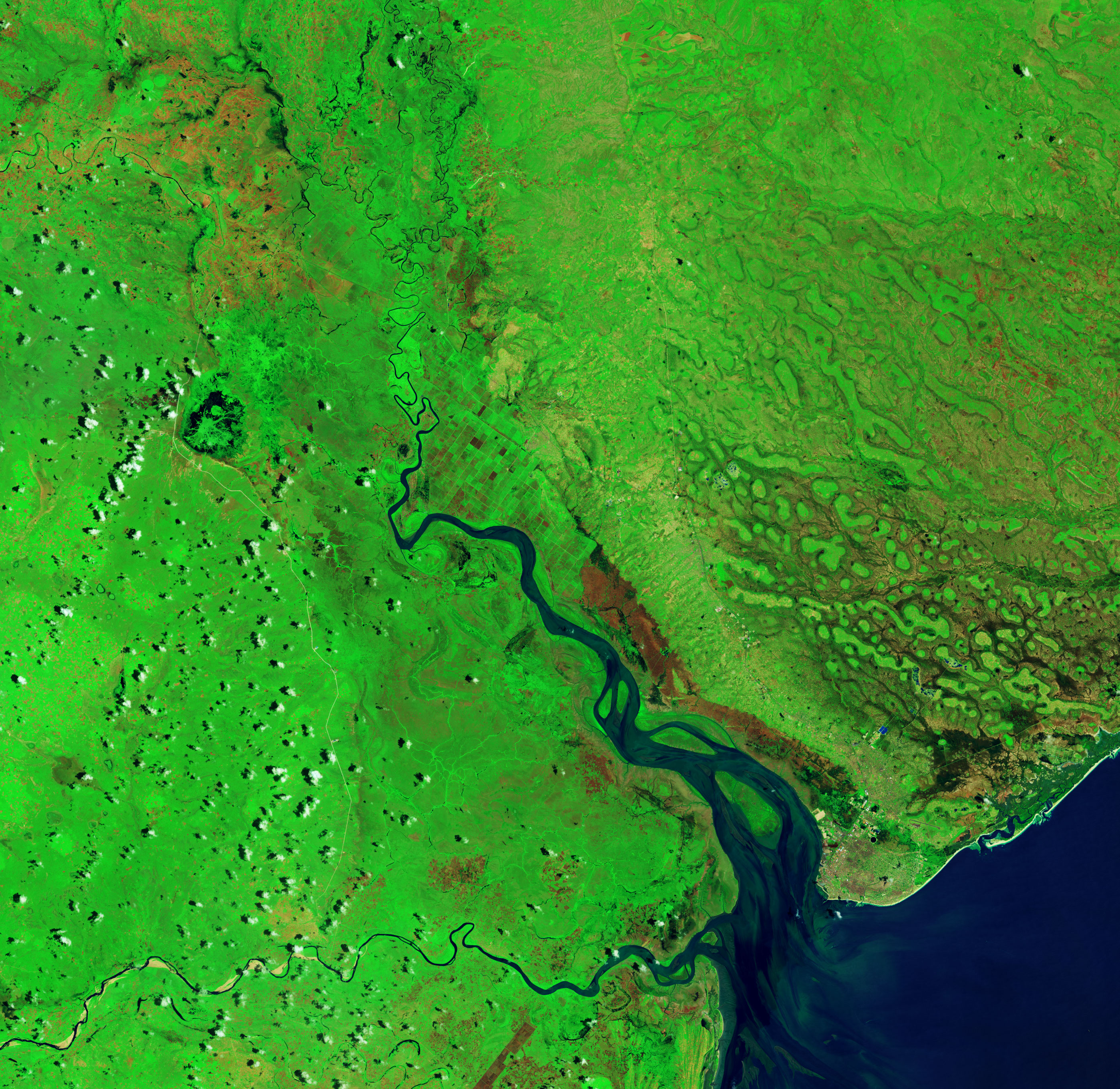
About 8.3 million people are estimated to be in need of humanitarian assistance in South Sudan in 2021, a 10% increase from 2020. Despite an official end to the civil war, there is a new wave of violence, perhaps instigated by politicians in the capital, perhaps due to a revival of old community grudges over land and cattle. Flooding since July 2020 has made the humanitarian and food security situation even worse, particularly in hard-hit Pibor and Jonglei. Over one million people have been affected by the floods, which have submerged homes, farmland and livestock (Figure 3). Our machine learning model is forecasting ongoing conflict throughout most of the country, including the parts of the country that have suffered the worst flooding. The model is now forecasting peace in the northeastern-most and northwestern-most parts of the country, a change from last quarter.
|
|
|
Figure 3: A section of the White Nile north of Juba, South Sudan shows that the area of water has increased between 2019 and 2020.
TURKEY: DROUGHT
In mid-January 2021 it was reported that water was at critically low levels across Turkey as it faced the most severe drought in a decade. Istanbul could run out of water in 45 days. WPS demonstrated using a number of satellite-based sources of information that the truth was both less dramatic and more worrisome. The current drought is the fourth in less than fifteen years, though not as severe as a couple of the other ones. This string of droughts is part of a pattern of declining rainfall across the Mediterranean that has been observed since the early 1970s. It is also consistent with forecasts of declining rainfall across the midlatitude regions of Europe and western Asia that will result from climate change. The drought has since eased, though it remains significant across parts of central and southern Turkey (Figure 4). A JRC drought indicator that focuses on exposure and vulnerability to drought showed that the risk of impacts on agriculture and on urban drinking water supplies had eased following ample precipitation during the second half of January 2021. Our model is forecasting emerging conflict in three small regions of southern and eastern Turkey. Compared with last quarter, however, there are many more regions of Turkey where the model is now forecasting peace instead of conflict. For a discussion of the dialogue process between Turkey and Iraq over the waters of the Tigris-Euphrates Basin, please see below.
IRAN: water OVER-ABSTRACTION
In January and February 2021, farmers in the central Iranian city of Isfahan staged several large rallies to protest the “denial of their water rights” from the Zayandehrood River. Due to increasing irrigation and water resources mismanagement in the basin, the river no longer reaches the city of Isfahan. This is not the first time farmers have staged protests in this region. In mid-2018, hundreds of farmers from the eastern part of the province stormed Isfahan, chanting, “America is not our enemy; our enemy is right here.” Media reported these protesters were met by police forces dressed in anti-riot gear and equipped with water cannons.
This is not an isolated problem in Iran. The drying up of lakes, rivers, and marshlands across Iran has become commonplace due to drought and resource mismanagement. Lake Urmia, once the largest lake in the Middle East and the sixth-largest saltwater lake in the world, is another case in point. Here, as elsewhere throughout Iran, food self-sufficiency policies drove overuse of water for irrigation. The lake shrank to 10% of its former size before staging a bit of a comeback in recent years, in part due to government policy and in part due to above-average rainfall (Figure 5).
Our model is forecasting emerging or ongoing conflict in several regions along the western border and in the southeast. Compared with last quarter, however, there are many regions of Iran where the model is now forecasting peace instead of conflict.
Figure 6 shows baseline water stress in Iran. In the regions of Isfahan, Lake Urmia, and so many others, we see that water stress is extremely high. When water stress levels are that high, we can expect to see rivers and lakes drying up and groundwater levels falling precipitously.
Figure 5: USGS-NASA Landsat satellites captured these false-color images of Lake Urmia between 1972 and 2014. Source: NASA's Goddard Space Flight Center.
NEW OR EMERGING DISASTER EVENTS
MOZAMBIQUE – CYCLONE ELOISE
Central Mozambique has been hit by a succession of powerful cyclones and tropical storms over the past two years. Climate change is said to intensify the rainfall associated with such cyclones. Cyclones Idai and Kenneth devastated the region in March and April 2019. Tropical Storm Chalane struck in December 2020 and Cyclone Eloise in January 2021. UNICEF reports that Cyclone Eloise “damaged and destroyed farmland, vital infrastructure and thousands of homes, dealing another devastating blow to families still trying to put their lives together after Cyclone Idai struck, less than two years ago.” According to the UN’s International Organization for Migration (IOM), nearly 442,000 people were affected by Eloise, over 43,000 people were internally displaced, and over 56,000 houses were partially or totally destroyed. Figure 7 shows flooding a few days after Eloise made landfall near the coastal city of Beira. The image from late 2019 is provided to compare the area under non-flooded conditions.
On March 14, 2021, United Nations Secretary-General Antonio Guterres called on the international community to help Mozambique tackle the "triple threat" of climate change, conflict and COVID-19. Conflict has plagued central Mozambique, with the dissident Renamo Military Junta recently conducting attacks in Manica and Sofala. While our model forecasted conflict in some parts of central Mozambique last quarter, it is now forecasting peace throughout all of central Mozambique. For a discussion of the deteriorating situation in Mozambique’s northernmost province of Cabo Delgado, please see section below.
 |
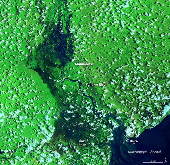 |
Figure 7: Non-flooded conditions (left) on December 27, 2019 vs. flooded conditions (right) on January 30, 2021. Source: NASA Earth Observatory images by Lauren Dauphin, using Landsat data from the U.S. Geological Survey.
IMPROVEMENTS OR DETERIORATION FROM PREVIOUS QUARTERS
MALI, niger, and burkina faso: PEACE AGREEMENTS and new attacks
In January 2021 the Centre for Humanitarian Dialogue (HD), a Swiss organization, announced the signing of three peace agreements between Fulani and Dogon communities in the Koro region of central Mali, near the border with Burkina Faso. The semi-nomadic Fulani herders and the mainly sedentary Dogon farmers have often feuded over access to land and water resources in the Inner Niger Delta and other regions of central Mali. These feuds erupted into violent conflict after armed fighters and jihadists pushed into the region over five years ago.
These and other peace agreements are not taking place under the auspices of the Malian state, however. They are being brokered by jihadist groups who are generally aligned with Fulani fighters and who require the local population to break with the Malian army, which is generally aligned with Dogon fighters. Unlike internationally-supported peace agreements that exclude jihadists, the ones brokered by the jihadists seem to last more than a temporary amount of time.
WPS partners in the region have seen a decrease in “international jihadist” involvement in Mali over the past few years and a transfer of leadership to local actors. They recommend efforts to try to understand these actors’ agendas, rather than paint the situation in black and white. They note that the current government of Mali is conducting a nuanced approach, hoping to negotiate with these jihadist groups in order to reassert state control.
The series of recent attacks in western Niger, as the country elected its new president (a rare example of democratic handover of power in the region), demonstrates that jihadist groups do not limit their actions to the territories of specific nation states. Insurgent groups have operated in the so-called Liptako-Gourma region since 2018. This region covers northeastern Mali, western Niger, and northern Burkina Faso.
Our machine learning model is forecasting ongoing conflict in some parts of central and northern Mali, western Niger, and northern Burkina Faso; however, there are many parts of these regions where our model is now forecasting peace instead of conflict.
AFGHANISTAN: JOINT SURVEY WITH IRAN
As we’ve reported in previous quarterly updates, relations between Iran and Afghanistan have deteriorated as Afghanistan’s Kamal Khan Dam nears completion. This dam along the Helmand River is expected to irrigate 174,000 hectares of land in three districts, supply water to the city of Zaranj, and generate nine megawatts of electricity for Nimroz Province. Iran contends the dam will limit flows into its country – water that its local communities and ecosystems rely on. Amidst this growing international tension, however, we may now be witnessing a diplomatic breakthrough. In early February, 2021 it was reported that an agreement had been reached to install advanced measuring instruments on the river to monitor implementation of and compliance with the 1973 water treaty signed between the prime ministers of the two nations. Our model is forecasting emerging or ongoing conflict throughout most of Afghanistan. In the Helmand River border region with Iran, the model is forecasting emerging conflict.
IRAQ: greater COOPERATION WITH TURKEY on the tigris and euphrates imminent?
In mid-March 2021 Turkish ambassador to Iraq, Fitih Yildiz, announced that a December 2014 memorandum of understanding between the two countries would soon enter into force. According to a report, the MOU includes 12 articles, “the most prominent of which [are] the emphasis on the importance of cooperation in the field of water resources management of the Tigris and Euphrates, determining the water share of each country in the waters of the two rivers, and… the importance of assessing water resources.” In previous quarterly updates, we discussed the impact that lower river flows were having on water quality in central and southern Iraq, which was in turn contributing to violent demonstrations in these regions. While our model is now forecasting peace instead of conflict in a few parts of central and southern Iraq, there are still a number of regions where the model is forecasting emerging or ongoing conflict.
MOZAMBIQUE: BEHEADINGS IN CABO DELGADO
A UN OCHA (Office for the Coordination of Humanitarian Affairs) report published in early March 2021 warned that the ongoing armed conflict in the three northernmost provinces of Mozambique, together with climatic shocks, disease outbreaks (including cholera), and extreme poverty have left over a million people in need of urgent humanitarian assistance and protection in Cabo Delgado, Niassa and Nampula. The intensification of the conflict in northern Mozambique has left nearly 670,000 people internally displaced in the three provinces by the end of December 2020. In mid-March, global media were reporting on beheadings of children as young as 11 by the local Islamist insurgent group, said by U.S. officials to have ties to the Islamic State (ISIS). The situation was further escalated when jihadists besieged the northern town of Palma. “Insurgents affiliated with the Islamic State group (IS) launched a raid on the coastal town [on March 24], ransacking buildings and murdering and beheading civilians.” Plagued by conflict and COVID-19, Cabo Delgado and Nampula provinces are also contending with high risk of drought impacts on agriculture (Figure 8). Our machine learning model is forecasting ongoing conflict in Cabo Delgado (as it did last quarter).
ISRAEL (AND FLORIDA): CYBER ATTACKS
According to a recent government report, water companies in Israel are unprepared for a cyberattack that could disrupt operations and possibly harm residential customers. This is despite an attack last year by hackers who attempted to increase the amount of chlorine in water supplied to residential areas in central Israel. The attack – which did not result in any tangible damage – was blamed on Iran. The incident was similar to a more recent hack into a water treatment facility system in Florida. In that case, the hacker attempted to increase the amount of sodium hydroxide in the system. The breach was quickly spotted by a facility employee, who foiled the attack. The model is not forecasting conflict in any part of Israel, nor did it last quarter.
OTHER REGIONS OF INTEREST
HONDURAS: hurricanes, FLOODING, and human displacement
In November 2020, Central America was hit by back-to-back Category 4 and 5 hurricanes (Hurricanes Eta and Iota). Hurricane Iota is only the second Category 5 Atlantic hurricane to occur within the month of November, since record-keeping began (the other was the 1932 Cuba hurricane). Honduras, in particular, was devastated by widespread inundation, destruction of property, and human displacement (Figure 9). The Honduran government reported over 357,000 people affected by Hurricane Iota, and over 61,000 people sheltered across 750 locations. Migration at the U.S. southern border began to surge in early 2021. Many migrants have cited the impact of the twin hurricanes as one factor among many prompting them to leave their countries for the United States. In the recent past, many migrants to the United States from Central America have also cited years of El Nino-related drought as a key reason for migrating.
TAIWAN: DROUGHT
A severe drought is beginning to impact water users across much of Taiwan (Figure 10). A recent media report notes that reservoirs in central and southern Taiwan have nearly “bottomed out.” In late March, the government issued a water supply “red alert” limiting access for non-industrial users in two counties in central Taiwan to five days a week. In the meantime, authorities are trying to implement numerous measures to conserve water. Of special concern is availability of water for the semiconductor sector, which relies on large quantities of clean freshwater. Taiwan Semiconductor Manufacturing Company (TSMC) is reported to have signed a deal for over 100 water tankers as the drought has worsened. Impacts to Taiwan’s semiconductor sector could disrupt global manufacturing supply chains and prove very costly.
TEXAS: WATER SUPPLY DISRUPTION
In February 2021, subfreezing temperatures from a winter storm overwhelmed the state of Texas’ electricity infrastructure, causing power outages for as many as 4.5 million homes and businesses across the state. The power outages forced water treatment plants offline. At the same time, freezing temperatures ruptured water mains and residential water piping. The pressure drop in the water system that ensued presented a danger of bacteria in the water supply. People were told to boil water or else had to go without water (because they lacked electricity to boil it). At the height of the water crisis on February 19, 15 million people across Texas lost access to clean water. Figure 11 includes an entry describing displacements of people from their homes in Texas. Hundreds of thousands of additional people from Oklahoma to Mississippi also lost water service. This case serves as a warning for other regions whose infrastructure may not be able to withstand temperature extremes. Such extremes will become more commonplace as a result of climate change.
US WEST: DROUGHT
In mid-March 2021 nearly half the United States was in drought and conditions were expected to grow worse, according to government forecasters at NOAA. The drought is expected to impact roughly 74 million people and will stretch from the Pacific coast to the Great Plains and upper Midwest. The Southwest will see the worst impacts (Figure 12.) This is a region that is increasingly said to be experiencing a “megadrought.” This situation does not bode well for the knock-on effects of drought, such as wildfires, which devastated large areas of the western United States last year.

the number of climate-related disasters is growing
There were a record 50 weather disasters throughout the world in 2020 that caused $1 billion or more in damages, according to insurance broker Aon. The findings of this report dovetail with those of an October 2020 UN Office for Disaster Risk Reduction (UNDRR) report, which found a “staggering” rise in climate-related disasters over the past few decades. Extreme weather events nearly doubled from 3,656 in 1980-99 to 6,681 in 2000-19. “The number of major floods more than doubled, from 1,389 to 3,254, and the incidence of destructive storms increased from 1,457 to 2,034.”
ABOUT WPS AND ITS QUARTERLY UPDATES
Water, Peace and Security (WPS) Partnership. The WPS Partnership offers a platform where actors from national governments of developing countries and the global development, diplomacy, defense, and disaster relief sectors can identify potential water-related conflict hotspots before violence erupts, begin to understand the local context, prioritize opportunities for water interventions, and undertake capacity development and dialogue activities.
The Global Early Warning Tool. Our Global Early Warning Tool provides the initial step in a multi-step process, employing machine-learning to forecast conflict over the coming 12 months in Africa, the Middle East, and South and Southeast Asia. So far it has captured 86% of future conflicts, successfully forecasting more than 9 in 10 “ongoing conflicts” and 6 in 10 “emerging conflicts”.[2]
Quarterly Updates. We are publishing Quarterly Updates to accompany our updated maps. These Quarterly Updates flag some of the hotspot areas we are tracking and describe what journalists and other actors are seeing on the ground. While we are primarily concerned with water- and climate-related conflict, the tool is designed to forecast any type of violent conflict (and can therefore be used by a variety of users interested in conflict).
Our multistep process. Early warning is very important, especially given limits to the number of problems that national and international actors can track and address at one time. Our Global Early Warning Tool ensures that emerging conflicts can get the attention they need, early enough that potential risks can still be mitigated. Our regional- and local-level tools then support the next steps in the process and can be used to verify (or disprove) global model forecasts, better understand regional and local conflict dynamics, and begin to identify opportunities for mitigating risk. WPS partners offer training and capacity development to global-, national-, and local-level actors to help them better manage risks. We can also help build constructive dialogues among parties to disputes (and other key stakeholders) that can engender water-related cooperation, peacebuilding, and design of conflict-sensitive interventions.
[1] The forecast comparison map of last quarter vs. current quarter compares forecasts made by the model, not actual circumstances. Comparing actual circumstances would require a separate analysis.
[2] The trade-off for this high recall is low precision for emerging conflicts. Around 80% of all emerging conflict forecasts represent false positives, that is, instances where conflict was forecast but did not actually occur. Ongoing conflicts are much easier to accurately forecast and have both high recall and high precision (<1% were false positives). We continue to work on improving the early warning model and expect that future versions will be able to better forecast conflict.